About the GTA Urban Emissions Project
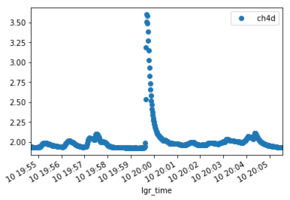
Our project aims to investigate methane gas emissions in the Greater Toronto Area (GTA). We are interested in quantifying the total methane emissions from the GTA as well as studying the nature of individual point sources throughout the GTA.
To do this, we use a combination of mobile in-situ gas measurements and remote sensing gas measurements. To make remote sensing measurements, we use two EM-27/SUN Fourier Transform Infrared Spectrometers (FTIRs) to measure the composition of the atmosphere above the GTA.
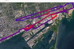
The in-situ measurements are made using a mobile laboratory consisting of a weather station and gas analyzer mounted on a bicycle trailer. We cycle around the city with the lab and update this website with real-time atmospheric data.
We are also interested in measuring air quality, and we have distributed several sensors around the city to measure particulate matter. See our Air Quality pages for further details.
We are monitoring phenology (the timing of plant growth) in our city as well, using hourly camera images both from the City of Toronto's traffic cameras, and from our own phenocams located in downtown Toronto.
Contact Us
Debra WunchUniversity of Toronto
Department of Physics, Rm 707A
60 St. George Street
Toronto, ON M5S 1A7
Website: https://sites.physics.utoronto.ca/debrawunch
Phone: (416) 946-0408
Fax: (416) 978-8905
Email: dwunch@atmosp.physics.utoronto.ca

Maps
Our data are collected, processed, and mapped in real time on our live map webpage so you can interactively see current air quality measurements in the GTA. We also have several static maps of previously collected data that you can see by selecting a day from the calendar dropdown menu at top of your screen.
Mobile Lab Instruments
To measure concentrations of greenhouse gases in the atmosphere, we use a portable LGR cavity ringdown spectrometer. To help with analyzing the data, we also measure several weather conditions as well as GPS position using an Airmar portable weather station.

Data
The Wunch Lab has a Dataverse archive of these data. Click the link below to download the data.